Not everything came up roses in my dive into historical data visualization.
For instance, some visualizations broke. The image on the left tells me nothing about the number of emigrants to Algeria from specific departments in France as expected.
It was also very difficult to upload a custom map in Tableau. First I tried importing a csv file of the French department geocodes from the French government. However, it wasn’t formatted properly, so that didn’t work. Then, our GIS expert at the Claremont Colleges Library, Warren Roberts, created a shapefile for me, which I uploaded into MapBox since Tableau can import MapBox maps. At that point, I discovered that Tableau only likes the standard maps that are preloaded into the online version of MapBox, but it might accept a custom map if it’s created in MapBox Studio Classic, the desktop version of MapBox. When I went to download this version, a popup appeared that asked if I was sure I wanted Classic because they now have an updated version. I selected, “Yes, I am sure.”
Once in MapBox Studio Classic, I connected my online and desktop accounts, but my custom map didn’t appear. The next step was to download the JSON file from the online version to be able to open in Studio Classic. The discoveries continued as I learned that MapBox Studio Classic could not open the zip file containing the shapefile and associated data, nor could it open the JSON file I downloaded from MapBox online.
Frustrated, I returned to MapBox online and uninstalled Studio Classic from my laptop. I had already created a custom access token and linked it to the project. From the home page, I clicked on the menu hamburger next to the map I created with Warren’s shapefile, selected “Share, develop, use” and scrolled down to the code to embed the map in Tableau.
You can see that Tableau has been selected in the options here. I am using Tableau 9.3.4, so, theoretically, this should work. I made sure my custom access code was selected up at the top of the page, and then copied the integration URL.
However, pasting it into Tableau’s MapBox Maps to use it as a background map yielded no change. My map still looks like this:
After two hours, I am giving up on this and returning to ArcGIS for this mapping project. Stay tuned for updates!
This is my first foray into data visualization as a historian, and I’ve been pleasantly surprised. Of course, as a mathematician, I know that visualizing data can be a powerful way to explore it. However, as a historian, I have to admit, I was a little skeptical. I thought it would simply be a good way to communicate information rather than analyze it. I was wrong.
The image to the right is merely visually interesting, but the Tableau dashboard below brings together some important insights that impact the argument I make about settler colonialism in French Algeria.
French Colonial Algeria Settlement Overview
Sources:
Data came mainly from secondary sources for these visualizations:
Figures for 1831-1840 (Troops and European Settlers) come from a chart in Jean-Pierre Bois, Bugeaud (Fayard, 1997), 363 in d’après T. Bugeaud, L’Algérie. Des moyens de conserver et d’utiliser cette conquête, Paris, Alger, 1842.
Figures for 1841 and 1851 (European Settlers) come from John Ruedy, Modern Algeria: The Origins and Development of a Nation (Bloomington: Indiana University Press, 1992), 69 which was adapted from Gallissot, L’Economie de l’Afrique du Nord (1969), p. 28, and selected censuses of the Service de Statistique générale.
Figures for 1840-1851 come from Jennifer Sessions, By Sword and Plow: France and the Conquest of Algeria (Ithaca: Cornell University Press, 2011), 85, whose chart is from Kamel Kateb, Européens, “Indigènes,” et Juifs, 38. Sessions notes that “figures show year-end totals, which were often exceeded during the summer and fall campaign season.”
Charles-Robert Ageron, Modern Algeria: A History from 1830 to the Present, translated by Michael Brett (London: Hurst, 1991), 25. Ageron’s total number for European settlers (25,000) seems more accurate than that reported in Bugeaud based on the trends in the table. Page 26 provides the European and French figures for 1848.
I then corroborated this data on immigration numbers with Tableaux de la situation des établissements français dans l’Algérie, France, Ministère de la Guerre. Paris, Imprimerie Royale, 1831-1850. CAOM F80 Series.
Data on emigrant origins and occupations come from Sessions, By Sword and Plow, 294-299.
Using these sources made getting started with data visualization much quicker since I did not have to decipher poor quality microfilm or illegible handwriting. Now that I know how useful this type of historical data analysis can be, I will use more data from my own archival research in subsequent explorations.
Analysis and Insights:
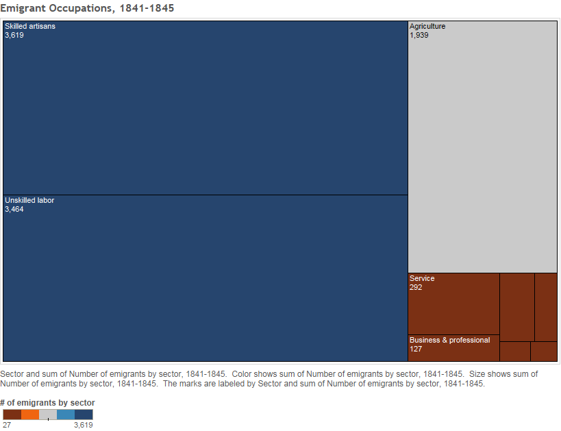
In the top left corner of the dashboard, the chart depicts the number of European settlers who worked in different sectors in Algeria between 1841 and 1845. Here’s a larger image to see the chart detail:
Scholars have argued that land was the single most significant factor motivating settlement in colonies, however, this visualization tells a different story about Algeria in the mid-nineteenth century (Cf. Veracini, Settler Colonialism: A Theoretical Overview, 2010). More than 75 percent of the emigrants worked in either skilled artisans who lived and worked in cities or unskilled labor, whereas only about 20 percent of the settlers were farmers who moved for access to more land. To drill down into this data, another chart helps us understand what might have drawn the unskilled laborers, or “working class” settlers to Algeria:
This chart reveals that most of the working class emigrants labored in road and building construction, demonstrating the French government’s desire to quickly expand access to more remote territories in the colonies, and create better roadways for the military to travel to extend French control. Furthermore, the rest of the working class laborers worked in sectors primarily located in cities rather than rural areas. John Ruedy, a scholar of Algeria, found that of the approximately 109,000 Europeans in Algeria in 1848, only about 15,000 were rural settlers, and of these, only 9,000 were French. (Ruedy, Modern Algeria, 71.) Thus, opportunities to work within their trades in cities proved to be a bigger draw for settlers than land.
From a qualitative analysis of sources, this finding contrasts with the American case. Settlers in present-day Indiana and Illinois, were, in fact most interested in land. Men frequently wrote to family members about the abundance, fertility, and affordability of the land. Not surprisingly, the United States government and land companies promoted this image through advertisements, newspaper articles, and books published primarily to market the newly acquired lands to potential settlers. Even though the French government advertised the province of Constantine, Algeria in much the same way, and a number of settlers moved to the region for the promised agricultural panacea, many more emigrants remained in the cities to ply their trades.
I am not the first to make the remarkable comparison between the colonization of French Algeria and that of United States’ territories. Rather, mid-nineteenth century French statesmen conscientiously used the United States as a benchmark of progress in their Algerian endeavor. This may account for at least some of the similarities in the colonies’ trajectories. However, it does not explain all of them, particularly those in the initial phases of conquest. The congruency between the stages of settler colonial development in the American Northwest Territory and French Algeria indicates the existence of commonalities in the formation of settler colonies more broadly.
Little Turtle, from United States Army Military History Institute
Native communities in both regions adopted similar approaches to resist, accommodate, negotiate, or avoid the colonizers. Recognizing the variety of options available and Indigenous leaders’ choices in their interactions with Europeans and Americans moves us beyond the resistance/accommodation dichotomy scholars have drawn in the past.[1] Through their leadership, Indigenous actors also shaped the form that settler colonies took. Their armed resistance forced the métropoles to govern through the military and required vast expenditures of money, men, and arms to hold the conquered territory. Cultural and religious norms pushed colonial administrators into accommodations, such as treaty negotiations, gifts, and the acknowledgement of Indigenous juridical practices – for their own people at the very least. In many cases, military officers were forced to work with Indigenous leaders to achieve their aims through active support, alliances, negotiating neutrality, or relying on their services as translators, guides, and scouts in unknown territory. Neither the French nor the Americans were ever able to fully eradicate Indigenous inhabitants from their desired lands, either in the period under consideration here or in subsequent years.
Settlers and the military in both locations took the conquest and occupation farther
Marshal Thomas Bugeaud (1784-1849), duc d’Isly, maréchal de France
than most metropolitan leaders originally intended, leaving the administration to recognize the fact of colonization after it had already begun on the ground. Officials were then left with the choice of accepting the colonies, such as they were, and continuing the work of the military and settlers or face international embarrassment by pulling out and risk the perception of weakness. Internal political pressures also compelled metropolitan politicians to send armed forces to these regions to maintain and eventually extend the occupation, but finding a way to pay for their services was a vexing problem for both métropoles.
Lack of adequate financial resources motivated metropolitan officials to promote and publicize settlement in the colonies. In both France and the United States, colonial administrators saw settlers as roots that could be planted and grow in the colonial soil to prevent its erosion from metropolitan control. Land in the colonies also served as payment for services rendered in securing it (for the soldiers and militiamen), circumventing the need to pay them in specie. This also supplied more settlers as bastions of colonial sovereignty and defenses against Indigenous land claims and armed reprisals.
In summary, settler colonies in the American Wabash Valley and Algeria resulted from a bottom-up process in which settler desires for land and greater economic opportunities compelled them to migrate (or emigrate) and stake their claim to these territories. This movement then served as a catalyst for initially makeshift colonial policies that only became systematized over time. The relationship between settlers and the Indigenous populations in both locations, as well as administrators’ responses to prevailing circumstances on the ground shaped the establishment of settler governments.
[1] For a small sample of this literature, see: Peter von Sivers, “Insurrection and Accommodation: Indigenous Leadership in Eastern Algeria, 1840-1900,” International Journal of Middle East Studies 6, no. 3 (July 1, 1975): 259–75; Chaudhuri and Strobel, Western Women and Imperialism; Edmund Jefferson Danziger, Great Lakes Indian Accommodation and Resistance during the Early Reservation Years, 1850-1900 (Ann Arbor: University of Michigan Press, 2009).
**All images in this post are in the Public Domain.
Photo taken by Flickr user Francesc González and used under CC BY-NC-ND 2.0 license.
First of all, I love this image. Let me tell you why (and how it relates to this post)… It provides a wonderful pictorial representation of where we now stand – at the edge of a precipice with nothing but a flimsy rope bridge to reach the other side. On what precipice, you may ask, are we standing? That of the deep gorge between mathematics and the humanities. On each side is solid rock – the disciplinary knowledge and epistemology of each area. To make it personal, each side of the rocky cliff represents my background in mathematics and history. The flimsy rope bridge between the two represents the current linkages and potential connections between the two (not yet substantial enough to be built out of the same rock). The rope bridge, I must admit, calls to my sense of adventure and curiosity. As I metaphorically step off solid ground to test the strength of the connection, the bridge holds, but it sways with the stiff breeze blowing through the chasm. My stomach drops a little as I look down and the terrifying expanse below, yet a sense of wonder and thrill shoots through me at the same time, and I tentatively begin inching my way along passage.
This post represents that first step. I’m not sure where it will take me or if I will reach the other side, but I believe it’s a worthy endeavor, nevertheless. A great journey cannot begin unless the first step is taken, right?
The first link, I’d like to point out between mathematics and the humanities is one that some mathematicians may be loath to admit – research and argumentation in both require creativity and breakthroughs are often the result of intuition. Now, that intuition is finely honed and based on years of disciplined study, but frequently, it is a hunch (an educated guess and a move that ‘feels’ right) that will lead us down new and interesting paths until we find either what we thought we were looking for or discover something entirely new.
The second link, though, is what interests me today. Before applying to graduate schools, I had a decision to make: pursue a Ph.D. in applied mathematics with a specialization in graph theory or pursue a Ph.D. in history. You can read more about why I chose history on the Author Info page, but it was a difficult decision. With the rise of digital humanities, there are clearer paths between my two disciplines. The most interesting, to me at least, is the door to new questions, analytical tools, and answers that graph theory has opened for humanities scholars through network analysis.
In his exploration of the effect of applying network theory to Shakespeare’s Hamlet, Franco Moretti writes,
No, I did not need network theory; but I probably needed networks. I had been thinking about Horatio for some time – but I had never ‘seen’ his position within Hamlet’s field of forces until I looked at the network of the play. … Basically, I used (or mis-used) the theory in the same way I had used cartography in the Atlas of the European Novel, and charts in Graphs, Maps, Trees: as a way of arranging literary data that presupposed a principle of order – but not a full conceptual architecture. (“Network Theory, Plot Analysis,” 2011, p. 10)
Moretti is describing the process of “hacking” or reimagining the uses to which a mathematical construct might be put – repurposing and adapting a conceptual tool to suit the needs of a different field, a different set of questions, and a different epistemology. This is innovative and valuable, in and of itself. From a theoretical standpoint, though, I do think it worth examining the specific moves Moretti and other humanities scholars make away from the original underpinnings of theories and analytic tools from STEM fields, for what purpose, as well as the distance between the initial ideas/approaches and their application in the humanities. This analysis may very well lead to insights about how these constructs from STEM might be tailored for specific humanistic fields.
I am not proposing a search for a unifying theory, but rather some guiding principles that might assist scholars in understanding how, why, and when to incorporate analytical tools from mathematics, specifically. Ideally, research in this area would help scholars to understand the mathematical principles behind the theories and methodologies they find attractive. My hope is that such a study would also reveal both what is lost and what is gained in the migration and necessary transformations of these approaches from one field to another. Network analysis seems a fruitful place to start.
Now it’s time to brush up on my graph theory! If I’m able to move this investigation forward, I will continue to post my findings here. Stay tuned!
Ashley Sanders becomes the new Digital Scholarship Librarian at the Claremont Colleges Library.
Nearly a year later, I am finally setting up my new Omeka site. It’s been an eventful year! In December 2014, I interviewed for and accepted a position as a Digital Scholarship Librarian at the Claremont Colleges Library. You can see slides from my interview presentation on trends in digital scholarship here.
Then it was time to move to Claremont and stop commuting from Westwood (near UCLA). Thus, I eliminated the dissertation and commute in one fell swoop and took the summer to recover from dissertating and moving.
At long last, I feel like I’ve acclimatized to my work in an academic library and the heat of the Inland Empire. This fall, I’ve been busy teaching a short 6-week “Intro to DH” course for faculty and graduate students at the Claremont Colleges and will begin a similar 5-week course for librarians on November 12. The bare bones of the website for the latter course are beginning to take shape at dhatccl101.com. Keep check in for updates! And for more on DH at the Claremont Colleges, check out claremontdh.com!
Now to return to a discussion of my new Omeka site… Omeka is installed on my domain, but now the hard work begins. Just as I counsel faculty and grad students embarking on new digital humanities projects, I want to spend some time reconsidering the purpose and audience for this site. Rather than import my old materials onto the new site, I want to carefully rethink the project and determine if my initial idea is the path I still want to pursue. The opportunity to teach a graduate digital history course on settler colonialism and collaborate with local indigenous communities will shape the objectives and design of the site, so I will know more in coming months and will post updates as frequently as possible. Watch this space for more!
In an animated discussion with other graduate students gathered around a homemade dinner in Aix-en-Provence, I discovered that I was not wandering alone in the darkness as I sought out methods to search the archives and organize my findings. Each of us had questions about the best methodologies and techniques to use in our research, as well as how to take advantage of the new digital tools available.
In my brief comments today, I will outline just a few of the challenges and opportunities that archival research in the digital age presents, along with several tools and techniques with which to tackle the problems posed.
My biggest challenge when I conducted dissertation research was an unusual one for a historian. I discovered an overwhelming mountain of sources on the conquest and colonization of Algeria in the French colonial archives and an equally intimidating number on the colonization of the American Midwest.
In addition to the paralyzing plethora of sources I found, I also faced two corollary dilemmas: (1) how to find relevant documents amidst the avalanche of materials in which I was immersed, and (2) how to organize everything once I found it. Sifting (or filtering) and organizing are two challenges that most historians are just now beginning to grapple with.
Problem 1: Abundance. Ever-expanding access to what historian Dr. William Turkel has dubbed the “infinite archive” of digital sources has opened up new vistas for research, but greater access to vast materials also poses a new set of challenges.[1] The shift from what the late Roy Rosenzweig has called, a “culture of scarcity to a culture of abundance” is a new experience for many historians that necessarily changes our workflow, as well as how we educate the next generation of historians.[2] As T. Mills Kelly has observed, both historians and students have to learn how to “mak[e] sense of a million sources.”[3] Therefore, digital tools are essential to tackling the challenges and opportunities that digitization’s abundance presents. In fact, this is the essence of Dan Cohen’s definition of digital history “as the theory and practice of bringing technology to bear on the abundance we now confront.”[4]
Problem 2: Filtering. A corollary problem is that of searching and filtering. To find both primary and secondary materials today, nearly all of us use web-based searches through a university library, the archives’ site we wish to explore, as well as search engines like Google. This means that whether or not we call ourselves “digital historians,” we are, by Cohen’s definition. But do we understand how the search capabilities of each of these portals functions to retrieve results? And, “why,” you may ask, “is this important?” Most significantly, we must understand that the algorithms that search engines like Google and Bing use to return results attempt to tailor or customize our results based on our web-searching and click patterns. The algorithms try to predict what we are most interested in seeing, which means that potentially relevant results are filtered out in the process. It also means we are seeing results from a narrower perspectival field. Both of these consequences present obstacles for a historian attempting to understand and interpret events and people, particularly if they are related to views, organizations, different from the researcher’s personal interests or political views. For example, a left-leaning male academic is interested in studying the conservative backlash to the women’s liberation movement of the 1960s will see very different Google search results from those of a right-leaning male or female scholar, which will introduce an unknown, invisible bias.
The difficulty of appropriately filtering results is a second hidden problem associated with digital searching.[5] In my own research, for example, I had difficulty tracking down whether a source referenced a father or son by the last name of De Lesseps. Attaching name references to data in the Name Authority File would clarify this issue and make search results more accurate. It would also address the problem of finding sources that contain alternate spellings of names, women whose names often change upon marriage, and pseudonyms. Linked Open Data, or the Semantic Web, offers great promise for historians, but we are still years away from seeing a fully linked web of data.
Even though filtering remains a challenge, scholars are able to more easily search for and find secondary works both within and outside their field. Advancements have been made in searching/finding tools, including customizable Google searches and alerts, tools like Serendipomatic, creating RSS feeds, and setting up digital library notifications. Historians can also find relevant content through regular expression searches, text mining, as well as document and topic clustering.
Possibility 1: A much wider range in the scale of historical inquiries now exists. We have access to increasingly better tools to help us find, read, annotate, analyze, process, store, and make connections between vast amounts of data. To conduct micro-histories, it is far easier to delve deeper into the historical record and make more nuanced connections through greater search features and accessibility of materials through digital archiving projects. Through new tools and developments in cyberinfrastructure for and by humanists, such as the SNAC Project (Social Networks and Archival Context), which reveals the social networks of historical figures to gauge an individual’s influence, historians have more ways than ever to investigate the impact of an individual or small group of people.[6]
According to Brown University social historian Jo Guldi, the reason we turn to the Digital Humanities is for projects of scale. She suggests that we are in the midst of a turn from micro to macro histories. Her own toolkit called Paper Machines, co-designed with Christopher Johnson-Roberson, is an example of the shift she describes. This digital tool assists historians in aggregating and analyzing numerous documents to examine how textual themes change over time. It is now possible to track various themes in specific journals through the decades, compare expansive text sets, and investigate larger patterns in the spread and influence of ideas over the longue-durée.[7]
Possibility 2: The digital environment in which we now work also makes possible larger collaborative, comparative, and interdisciplinary projects. In my own work, as one example, I am developing a digital repository for materials related to settler colonialism that also allows scholars to build online exhibits, including geospatial temporal exhibits. It is my intention to use the Omeka platform to facilitate such collaborative, comparative projects with scholars from many different locations. This ambitious project would not be possible without a digital hub that allows for easy communication and the sharing of resources.
The new H-Net Commons is another example: Every day scholars are working together to create innovative projects on the new Drupal platform. Some networks, like the American Studies network, are creating their own image archive. Others are collaborating across networks to facilitate and host important conversations (H-Material Culture and SciMedTech), and we are periodically developing “crossroads” networks for even larger collaborative undertakings. The first crossroad network was devoted to this past summer’s World Cup, but the most recent one focuses on World War I and is even more robust with multiple networks contributing content, projects, pages, syllabi, and discussions.
In art history, the Getty Research Institute is building a scholar workspace as an open source digital platform with accompanying toolset, as well as technical and methodological manuals. The digital workspace and tools tailored specifically to the study of visual objects will enable scholars to collaboratively analyze digital representations of primary art objects and create born-digital publications.[8]
In the early stages of my research, I experimented with Zotero, NoteBook, and Nota Bene. It took months of trying out different tools and reading all of the articles I could find on digital workflows to create one that was comfortable and appropriate given the limitations of my hardware and time. To create reference files of the sources I found, I eventually settled on taking digital photos of my sources, collating related pages from each document, tagging, and filing them. I also moved all of my relevant notes into Evernote and began adding tags. As I conducted research, I took notes in Evernote about how the contents of each microfilm and file box related to my research, essentially creating my own finding aid. It’s a simple system that has worked relatively well, but there are many things I will do differently in the future, including creating a database of my sources, as Rachel will describe next. To address the challenges of abundance and organization, Rachel will discuss how database management and writing software can be used to make sense of historical sources once we find them.
[2] Roy Rozenzweig, “Scarcity or Abundance? Preserving the Past,” Clio Wired: The Future of the Past in the Digital Age (New York: Columbia University Press, 2011).
[3] T.M. Kelly, Teaching History in the Digital Age (Ann Arbor: University of Michigan Press, 2013); http://bit.ly/1GMWCeo.
I just wanted to provide a brief update and announcement: The first stage of my project, Settler Colonialism Uncovered, will be moving from the server at Michigan State University. I will forever be grateful to MATRIX and the Cultural Heritage Informatics Initiative for the training and first digital home they provided. With the knowledge and confidence the supportive staff at MATRIX inculcated, I will be setting up the site on my own server to make site maintenance easier in the future. Watch this space for further updates and a link to the new site once it is up and running! If you have any questions, please feel free to email me [ashleys at msu.edu].
Over the past year, I have been hard at work revising and refining chapters of my dissertation. As with most projects of this magnitude, there are many more stories that can be told within the, albeit capacious, confines of the manuscript. Stay tuned for more about the events that unfolded in the American Midwest and French Algeria as each became transformed into settler colonies.
What would a map of French colonial Algeria or the American Midwest look like if we took a humanistic epistemological approach? How would such a map change if it took into consideration the humanistic notion that space is a construct influenced by perception (of travel times, of fear, of violence, of land rights, of agricultural production, of relations with one’s neighbors, etc.)? What kind of information would such a map yield?
What if we could create maps that represented settler’s perception of space and Indigenous perceptions of that same space? What might such a comparison offer the scholar of settler colonialism?
This brief post is a thought experiment based on Johanna Drucker’s thought-provoking article, “Humanities Approaches to Graphical Display” (2011). Drucker calls into question the uncritical application of data visualization tools to humanities projects. The digital graphical displays in common usage have been developed for and by social and physical scientists and therefore reflect epistemologies in direct opposition to those of the humanities:
Realist Assumptions & Epistemology
Humanist Assumptions & Epistemology
Observer-independent
Observer-dependent
Data (given information, facts)
Capta (information taken, interpretations)
World as-it-is
World as a construction
Knowledge is fact – based on observer-independent, verifiable, unalterable data
Knowledge is constructed – based on observer-dependent, subjective, interpretations of information
Consequently, Drucker argues,
“what is needed is not a set of applications to display humanities ‘data’ but a new approach that uses humanities principles to constitute capta and its display. At stake … is the authority of humanistic knowledge in a culture increasingly beset by quantitative approaches that operate on claims of certainty. … The digital humanities can no longer afford to take its tools and methods from disciplines whose fundamental epistemological assumptions are at odds with humanistic method.” (Paragraph 6, emphasis in the original)
I would like to take her argument a step further. It is essential to apply humanistic epistemology and methods to the display of capta, and, especially for scholars of colonialism, to incorporate Indigenous ways of knowing and seeing in digital visualizations. It is this idea that prompted my earlier pair of questions about how settlers and Indigenous peoples viewed space, and it is a question I am currently tackling in my dissertation. A graphical depiction of each would greatly assist a textual explanation.
For instance, I could use a series of maps of Vincennes, Indiana and the surrounding territory during the last quarter of the eighteenth century to demonstrate how French settlers, Indigenous inhabitants, and newly arrived Americans perceived this space, what influenced their perceptions, and how their views changed over time. In 1776, the village was comprised of roughly sixty French and French-Indian families who saw its borders as permeable and perceived their town as one among a network of French and Indian (and French-Indian) communities, connected by kinship ties, trade, and the navigable river system. However, when Americans arrived in the region, they often fortified their towns, erected visible borders in fences and gates, and created defensive cultural boundaries between themselves and the French and Indian inhabitants. American perceptions of the same space focused on their isolation from the states and from centers of American political and cultural activity along the Atlantic coast. Their perceptions were also influenced by the notion that they were surrounded by hostile Natives on all sides and therefore involved in a common (American) defense of land they viewed as rightfully and legally theirs.
While Indigenous views of land were initially expansive and porous, they soon began to shrink in the face of American encroachments and increasing racially-based violence. Under the perceived persistent threat the Americans posed, Native civil and military leaders’ perceptions of their territory shrank to parallel American views. Cartographic depictions of notions of shrinking space, of military and cultural isolation based on increasing violence, and the threat Indigenous, French, and American communities felt in proximity to the others would be a powerful presentation of documentary evidence and would complement the textual argument. Such graphical displays would also honor my intention to demonstrate Indigenous perceptions, in addition to those of the settlers, to move beyond black-and-white portrayals of good/evil actors toward a complicated and empathetic understanding of the motivations, hopes, and fears of multiple actors in this shifting colonial landscape.
How scholars define the Digital Humanities is as ongoing and fraught conversation. Here I offer a simple working definition to continue the conversation about its definition and present my own approach to the field. It is not meant to be exhaustive or all-encompassing. Please share what you believe to be the essence of DH in the comments section below!
DH is the study, exploration, and preservation of, as well as education about
human cultures, events, languages, people, and material production in the past and present
in a digital environment through the creation and use of dynamic tools to
“Settlers are not born. They are made in the dispossessing, a ceaseless obligation that has to be maintained across the generations if the Natives are not to come back.” — Patrick Wolfe.[1]
“Map of Kentucky, Drawn from Actual Observations by John Filson,” 1793
In this post, I examine how American colonists became settlers through the process of invoking their perceived sovereignty to dispossess the Indigenous population and claim rights to land in Kentucky and the Ohio River Valley. In the North American British colonies, settlers moving west across the Proclamation Line of 1763 onto Native American lands necessitated the Treaty of Fort Stanwix of 1768 (as well as subsequent treaties) and increased tensions between American colonists, Indigenous communities, and the British imperial administration. American desires for land both prompted rebellion from their own sovereign and motivated the newly forming United States to become a settler colonial state in its own right.
The American exploration of Kentucky (which contemporaries also referred to as Kentucke) began in 1767 when John Finley, a trader from North Carolina, and others traveled through the territory. Two decades later, contemporary historian John Filson, described Kentucky as the “Dark and Bloody Ground,” or “Middle Ground” due to the violence that erupted over its possession.[2] After conflict arose between the Anglo-American traders and their Native trading partners, the American colonists were forced to return home. Upon arriving at his homestead in North Carolina, Finley relayed his discovery of the Kentucky territory to Daniel Boone, a veteran of the French and Indian War (1754-1763), militiaman, frontiersman, and explorer. Boone later set out with other adventurers to explore the Kentucky territory in 1769. Despite the deaths of his companions due to illness and Native American attacks, Boone remained in the region until 1771. Filson observed that at about the same time:
Kentucke had drawn the attention of several gentlemen. Doctor Walker of Virginia, with a number more, made a tour westward for discoveries, endeavoring to find the Ohio river; and afterwards he and General Lewis, at Fort Stanwix, purchased from the Five Nations of Indians, the lands lying on the north side of [the] Kentucke [River]. Col. Donaldson, of Virginia, being employed by the State to run a line from six miles above the Long Island, on Holstein, to the mouth of the great Kenhawa [River], and finding thereby that an extensive tract of excellent country would be cut off to the Indians, was solicited, by the inhabitants of Clench and Holstein, to purchase the lands lying on the north side of the Kentucke river from the Five Nations. … [3]
While the language of “purchasing” lands from the Native inhabitants would seem to imply a recognition of Indigenous land rights and sovereignty, the purchases were no more than a gloss of legitimacy to cover the questionable means used to secure Native land for American settlement. Often, Americans treated with Native leaders who had no claim to the lands they sold to speculators. In the Treaty of Fort Stanwix, for example, the Six Nations (Iroquois Confederacy) sold lands that included Shawnee and Delaware territory to the Anglo-Americans without the consent of these tribes. Consequently, these communities were outraged when Americans began settling on their hunting grounds, claiming they had a right to be there. The appearance of a legitimate sale was enough justification for the settlers who moved onto Shawnee and Delaware lands. Not only did the sale validate their claim to land rights, but it also affirmed (in settlers’ eyes, at least) their sovereignty. Settlers encroaching on Indigenous lands viewed their reprisals as grounds for attacks on Native communities. Settler counter-attacks were often unsanctioned by the government but conveniently presented opportunities to compel greater land cessions, as happened in Lord Dunmore’s War in 1774 and the subsequent Shawnee land cessions.
Lord Dunmore’s War: The Battle for the Ohio Valley Begins
In January 1773, Virginia surveyor George Rogers Clark wrote to his brother to inform him of the land he had claimed in the region southwest of Fort Pitt and its prospects. The country “setels very fast” and people had already claimed lands down to the Scioto River 366 miles below Fort Pitt, Clark reported. As his survey partner, Roy observed earlier, the land was valuable, and Clark had already received “an offer of a very considerable sum” for his place. Even his surveying endeavors in the region were lucrative.[4] Americans could not wait to get their hands on the fertile Bottomlands along the Ohio River and its valley. Increasing settlement in the western regions of Pennsylvania and Virginia colonies brought more Americans into contact with Native inhabitants. Tensions grew as settlers continued encroaching on Native lands, initiating violence out of fear and growing racialized hostility.[5]
When Virginia surveyors began moving into Kentucky in 1773 and 1774, the Shawnee chiefs admonished the British that they could not be held responsible for what their young men might do when they met the white surveyors on their hunting grounds. Despite the warnings, the surveyors continued their exploration and their plans for settlement, as Clark recounted: “The country was explored in 1773. A resolution was formed to make a settlement the spring following, and the mouth of the Little Kenaway [Little Kanawha River] was appointed the place of general rendezvous in order to descend the river from thence in a body.”[6] Despite rumors of Indian attacks, Clark described “the whole party [as] enrolled and determined to execute their project of forming a settlement in Kentucky.”[7] However, not a single American discussed these plans with neighboring tribes, believing that the Treaty of Fort Stanwix (1768) granted them rights to these lands. Only the Six Nations were signatories, however, and as the Shawnee warnings demonstrate, other nations affected by the treaty protested its injustice. Resisting the Iroquois and American imposition of land cessions, the Cherokee even forced American surveyors to relocate the boundary initially set in the treaty to one Cherokee tribal leaders agreed upon.
From late 1773 through early 1774, Captain William Russell, an early Kentucky settler and part of Daniel Boone’s original entourage, sent out scouts to define this line between the Americans and Cherokee. He instructed that they should first figure out what the Indians’ intentions were. If they were for war, he admonished them to give him the “most speedy Acct thereof.” If they made no such discovery, they were to “find the boundary Line between us and the Cherrokees.”[8] While surveying, capture was entirely possible, a fate Russell was all too aware of, having lost a brother to an Indian attack several years before. Acknowledging this possibility, Captain Russell warned the surveyors to
avoid acting toward [the Indians] in a Hostile manner; unless in cases of the last extremity; because the least Hostility committed by You, at this Time when the Indians appear ripe for War; [would] not only blast our fairest hopes of Settleing [sic] the Ohio Country; and be Attended with a train of Concomitant Evils; but doubtless, involved the Government in a Bloddy [sic] War.[9]
The captain rightfully worried that Americans’ irresponsible, violent actions might stir up a war and impede settlement plans. In fact, his words foreshadowed precisely what he feared.
In April 1774, the threat of Indigenous attacks prompted Lord Dunmore, British Governor of Virginia, to issue a proclamation calling upon the Virginia militia to protect Kentucky settlers against Native raids on the interlopers. His statement also asks the militia to protect settlers’ right to the land which they claimed:
[The] settlement is in danger of annoyance from the Indians also; and it being necessary to support the dignity of his Majesty’s Government, and protect his subjects in the peaceable enjoyment of their rights, I … order and require the officers of the militia in that district, to embody a sufficient number of men to repel any insult whatever…[10]
At about the same time, Dr. John Connolly, who had declared Pittsburg to be under Virginia’s jurisdiction and protection, sent a letter to Captain Michael Cresap
letting us know that a war was to be apprehended and requesting that we would keep our position for a few days, as messages had been sent to the Indians, and a few days would determine the doubt. The answer he got was that we had no inclination to quit our quarters for some time. That during our stay we should be careful that the enemy should not harass the neighborhood that we lay in. But before this answer could reach Pittsburg, he sent a second express, addressed to Capt. Cresap, as the most influential man among us, informing him that the message had returned from the Indians that war was inevitable, and begging him to use his influence with the party to get them to cover the country by scouts until the inhabitants could fortify themselves. The reception of this letter was the epoch of open hostilities with the Indians.[11]
Two days later, on April 27, Captain Cresap’s force pre-emptively attacked a small band of Shawnee at Pipe Creek, killing and scalping one and incurring one significant injury among themselves. Several days after that, a number of Cresap’s force led by a man named Greathhouse murdered a group of innocent Mingo, including members of Mingo War Chief Logan’s family at Yellow Creek, launching events that would lead to the outbreak of Lord Dunmore’s War.
Some scholars maintain that Lord Dunmore and John Connolly intentionally planned the massacre to incite an Indian war in the Ohio Valley and open up more land for settlement. While wars between Anglo-American colonists and Native Americans offered a pretext for the colonists to punitively expropriate more land in the peace negotiations that followed the battle, the evidence does not suggest that Lord Dunmore and Connolly intentionally coordinated settler attacks to instigate a conflict for this purpose.[12] However, though they may not have masterminded the attack against Logan’s family, their actions set the stage for, and took advantage of, the violence that ensued. Dunmore called up the militia and Connolly set American nerves on edge with rumors of Indians on the warpath. Sources on the ground, including Captain Russell and his scouts, made clear that while Indian communities were watchful, there were no plans in place to launch attacks against the American settlements. At the same time, Captain Russell alluded to the possibility that one act of violence against the Indians could ignite a war. The atmosphere was ripe for violence, and Lord Dunmore and Dr. Connolly took advantage of it, knowing a war might give them the grounds necessary to “terminate the presence of [the Shawnee and Delaware] in Kentucky and western Pennsylvania.”[13]
Pennsylvania newspapers and correspondence from the contested lands reported the results of Shawnee and Mingo retaliations against the settlers:
May 30, 1774: “The Shawnese have raised 20 warriors to strike the Virginians, who sat off last Monday. I fear all the traders are killed at the Shawnese towns, as there was a party of Mingoes gathered for that purpose.”[14]
June 12, 1774: “We have great reason to be no longer in suspense concerning a war with the Indians, as they have already been guilty of several massacres; on Saturday, the 4th inst. were killed & scalped by them one Benjamin Spear, his wife & six children, on Duncard Creek; and the Monday following one Henry Wall, within sight of a fort that is built on Muddy Creek; one Keener, near the same place; and one Procter, near Grave Creek; there was also one Campbell, lately from Lancaster county, killed & scapled at New Comer’s -Town by the Mingoes.”[15]
June 22, 1774: “…When the News of the peoples being killed at Copper creek proved false several of the militia were assembled to go over there, and it was said they were sorry, exceedingly so, that it did prove false. So desirous are some of them for an Indian War; tho I can’t help fearing that it is the most worthless…”[16]
Events finally came to a head at the inaptly named Point Pleasant on October 10, 1774, where about 1000 militia had encamped several days before. Believing themselves safe and “a terror to the Indian Tribes on the Ohio,” the gathered forces of Shawnee, Mingo, and Delaware nearly caught them off guard.[17]
After hearing a good S[e]rmon Preached by the Rev. Mr. Terrey went to Repose [wit]h Our G[u]ards Properly Posted at a Distance from the camp as usual[,] little Expecting to be attack[e]d by any Party of Enemys as we looked upon them to be so much inferior to us in Number, but they taking the Advantage of the Night the[y] Crossed the Ohio on Rafts & [Posted] themselves Within one mile of our Camp where the[y] lay till morning[18]
However, a small hunting party discovered the Indians’ encampment before sunrise on the morning of October 10; one man was killed, but another escaped to warn the militia.
So fierce was the fighting that most accounts number the Native forces between 800 and 1000, but Captain John Floyd estimated their number to actually be closer to 500 based on the footprints left behind after the battle and the number of rafts reported on the river. Colonel William Christian arrived around midnight the night after the battle, collected stories from officers and militiamen and sent a report to Colonel William Preston, observing:
From what I can gather here I cannot describe the bravery of the enemy in the battle. It exceeded every mans expectations. They had men planted on each river to kill our men as they would swim over, making no doubt I think of gaining a complete victory. Those over the Ohio in the time of battle called to the men to ‘drive the white dogs in’. Their Chiefs ran continually along the line exhorting the men to ‘lye close’ and ‘shoot well,’ ‘fight and be strong.’ At first our men retreated a good ways and until new forces were sent out on which the enemy beat back slowly and killed and wounded our men at every advance Our people at last formed a line, so did the enemy, they made ma[n]y attempts to break our lines, at length our men made a stand, on which the enemy challenged them to come up and began to shoot. …Our men could have forced them away precipitately but not without great loss, and so concluded to maintain their ground all along the line. Which they did until Sundown, when the enemy were supposed to be all gone. Our people then moved backward, scalping the enemy and bringing in the dead and wounded…Late in the evening they called to our men that tomorrow they [would] have 2000 men for them, to fight on for they had 1100 men as well as them. They damn[e]d our men often for Sons-of-Bitches, said ‘Don’t you whistle now’ (deriding the fife) and made very merry about a treaty. [19]
Despite the displays of bravado, the allied Native forces retreated with as many of their dead and wounded as they could carry. They scalped or buried the rest of their dead compatriots on the battlefield, or threw them into the river to prevent them from falling into enemy hands. Then they disappeared into the night.[20]
Within a week of the Battle of Point Pleasant, Virginia’s colonial governor, Lord Dunmore reported that he had concluded a treaty with the Shawnee chief Cornstalk. With the combined might of his and Captain Lewis’ forces, Dunmore marched to the Shawnee villages on the Scioto. Through the machinations of British Indian agent, William Johnson, the Native confederacy that the Shawnee had orchestrated broke apart, leaving them alone and outnumbered. Faced with few alternatives, the Shawnee agreed to Dunmore’s peace terms and ceded their territory southeast of the Ohio River.[21]
By April 1775, George Rogers Clark reported to his brother that he had found employment as a Deputy Surveyor under Captain Hancock Lee. He was “to lay out Lands on [the] Kentuck for [the] Ohio Company at [the] rate of 80£ per year and [the] privilegde [sic] of Taking what Lands [he wanted].”[22] His missive of July 1775 is representative of many settlers’ response to the Kentucky territory. Clark observed, “a richer and more Beautifull Cuntry than this I believe has never been seen in America yet … I am Convinced that if [Father] once sees [the] Cuntry he never will rest untill he gets in it to live.”[23] Glowing reports of the beauty and fertility of the land encouraged increasing numbers of American colonists to cross the mountains and seek out their own piece of this land of opportunity. As they crossed the Cumberland Gap and claimed a plot of ground as their own, American colonists became complicit in Indigenous dispossession and were thenceforth transformed into settlers.
Conclusion
Following the Treaty of Fort Stanwix in 1768, the Shawnee, Delaware, and Cherokee protested the illegality of the Six Nations’ supposed sale of their lands. Their response indicates the heterogeneity of Native American tribes, which is important to keep in mind when contemporary Americans lumped all Indigenous peoples together under the misnomer, “Indian”. It also reveals the divisive and competitive nature of land cessions among Native communities as each jostled for greater protections of their own homelands at the expense of others’ through the early 1770s. (As the threat became more widespread and it became apparent that none were safe from avaricious American speculators and squatter-settlers, Indigenous leaders began to seek a united Native front during and, especially, after the American Revolution.)
Heedless of the significance of Indigenous protestations, Anglo-American colonists moved onto Native lands between 1768 and 1774 using the Treaty of Fort Stanwix as a “legal” justification for their claims. Believing the treaty affirmed their sovereignty over the region south of the Ohio River and backed by Lord Dunmore, American militias formed to protect their claims against Native efforts to repossess their own lands. Over the course of these six years, Anglo-American colonists became American settlers through the process of dispossessing the Native communities of Kentucky and the Ohio River Valley territory.
Through this transformation, they acquired a distinct identity that scholars today can retrospectively define as “settlers,” but also one they themselves defined at the time. Their understanding of themselves as Americans and not as British colonists, did not come about until the British-instigated Indian raids of 1777 and 1778. Nevertheless, prior to 1777, they understood that crossing the Cumberland Gap and making homes in the backcountry distinguished them from their peers who remained on the eastern side of the Alleghenies. They were “frontiersmen” (and women) and “adventurers” who embraced a simpler life and established democratic forms of local government, policing, and justice as an expression of political ideals and as models for their eastern cousins. They were willing to risk everything, even their lives, and confront any obstacle, including competing Indigenous claims for the material wealth and security that the western lands promised.
In settlers’ minds, their hard work to build homes, break ground, and cultivate fields entitled them to the lands they claimed according to squatters’ rights. Ignoring the fact that the land they acquired was already carefully managed and therefore value-added, settlers maintained that their improvements validated their sovereignty. Their confrontations with Indigenous inhabitants proved their mettle, their worthiness to settle the land, from which grew the myths about the hardy, independent backwoodsmen whose interactions with the Native population transformed them into Americans, according to nineteenth-century historian Frederick Jackson Turner. However much or little these Americans resembled their Native neighbors, it was the act of continual dispossession that resulted in the transformation from British colonists to American settlers.
The veneer of legality that the Treaty of Fort Stanwix was believed to provide the expropriation of Indigenous lands falls apart under scrutiny. However, it created the myth of American land rights. That was enough to prompt adventurers, land speculators, and families in search of economic advancement to stake and defend their land claims. The Battle of Point Pleasant did not end the contest for the Ohio and, later, the Wabash River Valleys; it was the opening salvo. The Shawnee land cessions in 1774 allowed more settlers into Kentucky, enriched Virginia land speculators, and provided the British with a pretext to encourage their Native allies to attack the American frontiers during the Revolution.
NOTES:
[1] Patrick Wolfe, “The Settler Complex: An Introduction,” American Indian Culture and Research Journal 37, no. 2 (2013): 1.
[2] John Filson, The Discovery, Settlement, and Present State of Kentucke (Wilmington: James Adams, Printer, 1784), 7.
[3] Filson, 7-8.
[4] GRC to Jonathan Clark, Ohio River Grave Creek Township, 9 January 1773, in IHC VIII, 2
[5] Peter Silver, Our Savage Neighbors: How Indian War Transformed Early America (W.W. Norton & Co., 2007).
[6] George Rogers Clark to Samuel Brown, 17 June 1798, in IHC VIII, 5.
[7] Clark to Brown, 17 June 1798.
[8] Capt. William Russell to Scouts. No Date [1773 or early 1774]. Draper Mss. 3QQ18. In Reuben Gold Thwaites & Louise Phelps Kellogg, Documentary History of Dunmore’s War (Madison: Wisconsin Historical Society, 1905), 5.
[9] Capt Russell to Scouts, in Documentary History of Dunmore’s War, 6.
[10] American Archives, Fourth Series: Containing a Documentary History of the English Colonies in North America from the King’s Message to Parliament of March 7, 1774 to the Declaration of Independence by the United States, I, (Washington, D.C.: M. St. Clair Clarke and P. Force, 1837), 283.
[11] George Rogers Clark to Samuel Brown, 17 June 1798 in IHC VIII, 7.
[12] Anthony F.C. Wallace, Jefferson and the Indians: The Tragic Fate of the First Americans (Harvard University Press, 1999), 7; Thomas P. Abernethy, Western Lands and the American Revolution (New York: Russell & Russell, 1959, 113-115.
[13] Wallace, Jefferson and the Indians, 7.
[14] “Delawares Friendly, Shawnee on Warpath: Extract of a letter dated Pittsburg, May 30, [1774].” Printed in the Maryland Journal, Saturday, 18, June 1774, in Documentary History of Dunmore’s War, 28.
[15] Extract of a letter from Fort Pitt, 12 June 1774. Published in the Pennsylvania Gazette, 22 June 1774, in Documentary History of Dunmore’s War, 36.
[16] Col Wm Christian to Col Wm Preston. Dunkard Bottom, Wed morning 22 June 1774, in Documentary History of Dunmore’s War, 43.
[17] Captain William Ingles to Colonel William Preston, 14 October 1774, Point Pleasant, in Documentary History of Dunmore’s War, 258.
[18] Captain William Ingles to Colonel William Preston, 14 October 1774, Point Pleasant, in Documentary History of Dunmore’s War, 258.
[19] Col William Christian to Colonel William Preston, 15 October 1774, Point Pleasant, in Documentary History of Dunmore’s War, 264-5.
[20] Colonel William Fleming to William Bowyer, no date, in Documentary History of Dunmore’s War, 256-7; Captain William Ingles to Colonel William Preston, 14 October 1774, Point Pleasant, in Documentary History of Dunmore’s War, 259.
[21] Jack M. Sosin, “The British Indian Department and Dunmore’s War,” The Virginia Magazine of History and Biography 74, no. 1 (January 1966), 47.
[22] George Rogers Clark to Jonathan Clark, Stewards Crossing, 1 April 1775, in IHC VIII, 9.
[23] George Rogers Clark to Jonathan Clark, Lees Town, Kentucke, 6 July 1775, in IHC VIII, 9-10.

 You can see that Tableau has been selected in the options here. I am using Tableau 9.3.4, so, theoretically, this should work. I made sure my custom access code was selected up at the top of the page, and then copied the integration URL.